top of page

Katherine Mistick
MS Thesis: Mapping Fire and
As a Graduate Research Assistant for the Utah Remote Sensing Applications Lab, I utilized remote sensing techniques and geospatial modeling to help understand and improve safety for those fighting wildland fires. My thesis research focused on using airborne lidar data and real-world fire management data, as well as python and R to assess methods for determining the visibility surrounding an active wildfire to make recommendations for wildland firefighter lookouts.
A copy of my defended manuscript can be found here.

2020-2022
Firefighter Visibility for Improving Situational Awareness
Abstract
Wildland firefighters assume exceptional risk while mitigating the hazards wildfires pose to life and property. While certain protocols and safety initiatives have been developed to improve wildland firefighters’ situational awareness, research has not yet focused on quantifying and mapping visibility that wildland firefighters possess surrounding an active wildfire. A major component of situational awareness during a wildland fire event is maintaining a line of sight with the fire and with the crew. This research seeks to compare methods for determining visibility at the scale of a wildland fire event, including fire visibility and crew visibility.

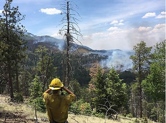
A wildland firefighter lookout. Photo by Allyson Bonk. Credit the U.S. Forest Service, Southwestern Region, Kaibab National Forest.
bottom of page